Death Valley is HOT

Photo by Athena on Pexels.com

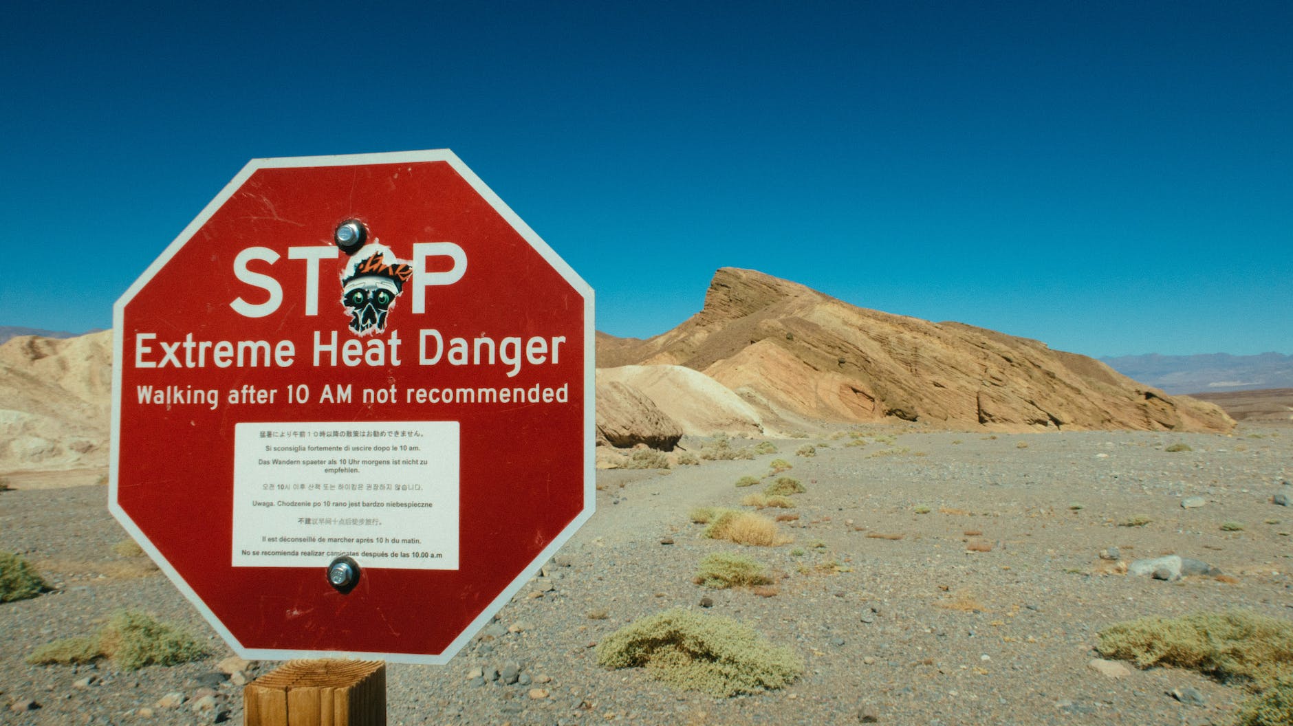
Right now, visitors are flocking to Death Valley National Park to experience the forecasted EXTREME heat.

Death Valley is projected to set a verified world record for the hottest temperature ever reliably recorded, with Furnace Creek expected to reach 131 degrees with a low temperature at night of 101 degrees.

I’ve been to Death Valley a few times. It’s an otherworldly and mysterious experience. It’s a whole mind/body connection, the kind of heat that permeates down to a soulful, cellular level. Along with the magnificent silence, there’s really nothing to compare to desert heat.

Ten thousand years ago, Badwater Basin, the lowest point in North America, was once a hundred-mile long lake. It’s now a vast expanse of salty ground.

When you visit Death Vally, make sure you stop at Artists Palette, a technicolor, kaleidoscopic display of multicolored rock in that makes you feel you’re at an art exhibit.

Of course, as with the rest of our country, there were Indigenous People here before us.

The Timbisha Shoshone Indians lived there for centuries before the first white man entered the valley. They hunted and followed seasonal migrations to harvest pinyon pine nuts and mesquite beans. To them, the land provided everything they needed and many areas were, and are, considered to be sacred places.

I always thank the first people when I camp or hike, no matter where I am.

The shamanic ground markings of Death Valley tend to be found in the more remote parts of this already remote region – probably the reason why any trace of them survives at all. They are ritual and magical features left by long-ago shamans, probably of the ancestral Pima and Shoshone peoples, and they are fragile, so much so that their precise locations are not advertised.

They take various forms – ritual pathways, shrines, vision quest beds, scraped ground markings, strange sinuous lines, and weird patterns of rocks.

Vision quest beds are remote, subtly-marked locations where an Indian brave or shaman would go to spend a solitary vigil seeking a vision – a personal spiritual gift. He would go without food or sleep for perhaps three or four days and nights until the vision came. If it came at all, it would most commonly be in the form of what we would call an auditory hallucination: he would hear a chant or song.

Ritual pathways are probably the rarest of the shamanic features. a loose group of boulders.

The most enigmatic of all the shamanic relics in the valley are markings etched into the hard, sunbaked ground (‘intaglios’) or laid out with small rocks on the surface of the ground (‘petroforms’). Such features are collectively known as ‘geoglyphs’. Both types in Death Valley mainly show meandering, abstract patterns, but a few seem to depict mythical creatures. (Curated from https://www.ancient-origins.net)

If you make it to Death Valley, no matter what season, take more water than you think you’ll need to stay well hydrated!

| sanctuary |

“Remember, the entrance door to the sanctuary is inside you.”- Rumi

Vermillion Cliffs Secret Cathedral: Photo by Enchanted Seashells

Moose in Grand Tetons

What a beautiful boy! He was almost completely camouflaged, resting in the cool grass, enjoying a late afternoon snack. Those antlers are magnificent, aren’t they?

I could have stayed there for hours, watching him in silence, but I had to go. He didn’t seem too concerned and kept eating and eating.

Great Basin National Park

For #throwbackthursday, this is one of my most favorite places to camp and hike.

Great Basin National Park is in Nevada. At 10,000 ft., Wheeler Peak is one of the tallest peaks in the country. It’s full of bristlecone pines and turkeys and solitude and serenity.

Here’s a beautiful alpine lake:

Memories of Joshua Tree

#ThrowbackThursday

One of my favorite places to camp and hike.

Love the rocks #JoshuaTree

Where I’d Rather Be…

…is right here, hiking in the desert.

#WordlessWednesday

Big Sur Magic

One of my favorite places on earth, and yes, the water really is that beautiful turquoise color.

Photo by Enchanted Seashells

McWay Falls is an 80-foot-tall waterfall on the coast of Big Sur in central California that flows year-round into the Pacific Ocean from McWay Creek in Julia Pfeiffer Burns State Park, about thirty-seven miles south of Carmel.

During high tide, it’s a tidefall, a waterfall that empties directly into the ocean.

The waterfall poured directly into the ocean until a massive fire, landslide, and highway reconstruction project near the area in 1983-84 filled the cove with enough material to form a sandy beach several dozen feet out.

The falls, creek, and canyon are named after Christopher McWay, an early settler and farmer from New York state who arrived in the area with his son Christopher Jr. around 1874.

The park itself is named after Julia Pfeiffer Burns (1868-1928), a local and legendary early pioneer and resident who impressed Helen Brown and had run a ranch in McWay canyon with her husband, John B. Burns.

#WordlessWednesday

Pinnacles National Park

Pinnacles National Park is an American national park protecting a mountainous area located east of the Salinas Valley in Central California, eighty miles southeast of San Jose.

Could the sky have been any more blue?

#WordlessWednesday

“Dear Deer, I’m so very sorry.”

In the blink of an eye. 

It’s true. You never know when the unexpected will occur.

We get up in the morning, drink our coffee and make plans for the day. Those plans NEVER include an auto accident or other unforeseen catastrophe.

I love to make lists:

-Traders for tofu, coffee, ginger tea…
-Go to the nursery
-Pick up prescription
-TJ Maxx
-Dentist @11am

Nowhere on any list does anyone ever pencil in, “be involved in a freak accident on a mountain road”. Or is that just me? Maybe a fatalist WOULD include that in a daily schedule. I dunno…maybe now I will.

I wasn’t the driver so I was literally paying zero attention to the road.

I was looking at all the photos I took and remembering how I got altitude sickness on the way up the twisty windy road and vomited everywhere (ick), but now we were relaxed and dusty and exhausted but happy to be heading back home after a few days of camping and hiking where we saw lots of deer and other animals.

I was startled to hear, “Oh, shit!” and the car swerved a bit and then we felt two large bumps that tossed us about and a large crash.

We pulled over to the narrow shoulder on the two-lane highway. Doing a quick triage, I determined that everyone was unharmed.

I turned around and saw a large piece of a car that we had apparently smashed into, but didn’t see a car. At that moment, a highway patrol car pulled up about fifty feet behind us. I ran out of the car and flagged down the patrolman. Fortuitously, he had been driving that way as part of his routine.

That’s when I saw it.

The deer.

The poor dear deer.

The poor dear dead deer.

When I wasn’t paying attention, this was how the scenario unfolded.

A deer ran across the road, the big truck in front of us hit the deer which caused his front bumper to fall off. That horrible man kept going; he never even stopped. The impact must have killed the deer instantly. We were unable to avoid hitting it as there was traffic all around and nowhere to go. So the two bumps we felt was us running over the already dead three hundred pound deer.

The patrolman said that was the third one that day. (There are lots of deer and not enough natural predators.)

Our vehicle was pretty messed up but it still ran and was OK to drive the rest of the way home but it was in the shop for three weeks.

After the poor dear deer was moved to the side of the road, I kneeled down and petted his head and told him how very sorry I was that he died.

I guess the moral of the story is that you never know when something bad is going to happen. As much as I like to predict all outcomes, sometimes it’s not possible to gaze in a crystal ball and see the future.

Honestly though, what kind of a horrible person hits an animal and doesn’t stop???

Out of respect for the deceased, I won’t post a pic of him, but here are other deer enjoying life.


Heaven on Earth: Camping and Hiking in the Laguna Mountains

The Laguna Mountains are only about an hour away east from the ocean in San Diego.

Most people go there when we have snow — at 6000 feet, it’s the highest point in the county.

It’s possible to surf in the morning, cross-country ski (or hike) in the afternoon, and drop down into the shimmering desert to experience the best of everything SoCal has to offer.

Late May to mid-June is the time of year when color explodes in the mountains and it’s not too hot to enjoy a strenuous hike while the air cools down comfortably at night.

It’s easy to get here: east on Highway 8 to Sunrise Highway.

We went mid-week before schools were out for summer vacation and we had the mountain pretty much entirely to ourselves.

Fragrant pines, Engelmenn oaks, wildflowers; deep  blue sky with a few white puffy clouds.

Amazing…gorgeous…magnificent…breathtaking…

There aren’t enough adjectives to describe the spectacular views.

We hiked Desert View Trail and Big Laguna Trail, about ten miles or so.

It was truly heaven on earth, one of those experiences where whispering was the only way to communicate-we didn’t want to mar the ultimate reverence for nature.

These are only a sampling of the hundred-plus pics I snapped and none of them do justice to this paradise.

This slideshow requires JavaScript.