“When I am silent, I fall into the place where everything is music.” — Rumi
Whew, it’s definitely time for a Rumi quote to bring down sky high BP.
Today is Martin Luther King Day and that petty psychopathic orange POS removed MLK Day and Juneteenth from the list of fee-free days for our national parks and replaced them with days like Flag Day (his birthday).
My governor, California’s Governor Newsom, countered by making over 200 California State Parks free on MLK Day.
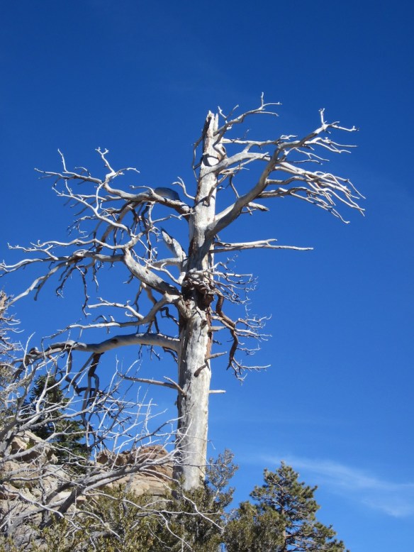
Enjoy this silent and stark tree from Mt. San Jacinto near Palm Springs, California.
I had another post planned for today but then this happened!
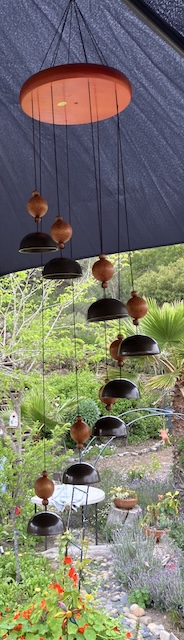
I was in a store looking at a wall of wind chimes (I love them so much). They were on sale which always gives me an added thrill.
Suddenly, ALL THE WIND CHIMES STARTED SWAYING BACK AND FORTH!
I had a split second realization that we were going to have an earthquake, and at that precise moment, there was a very loud bang, like the ceiling and the lights were going to crash down around us — definite sky is falling vibes.
The entire store was rocking and rolling. People started to rush out the front doors as we’ve been taught. I thought about it for a couple seconds and decided not to follow the crowd because I had a few things in my cart for the Angels and didn’t want to have a wasted shopping trip. In the face of potential danger, my shopping obsession prevailed lol.
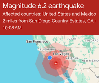
Phone alarms were going off like crazy with initial reports of a 6.2 earthquake which is pretty big. Later on it was downgraded to a 5.2, but it felt more powerful than that. It was reported as having a Modified Mercalli Intensity (MMI) of VI, which is classified as “strong”. There were several aftershocks all afternoon; not as scary.
A woman near me was shaking, visibly upset. I asked her if she needed a hug, she said yes, so I gave her one, hoping it would calm her down a bit. I agree it was definitely upsetting.
Should I stay or go? I decided the planets and the universe had given me an unmistakable SIGN that I needed to buy that chime I had been looking at, so I did.
The last BIG earthquake here was the 2010 Baja California quake that occurred on April 4 (Easter Sunday) with a magnitude of 7.2 and a maximum Mercalli Intensity of VII (very strong). Including today and our 4.2 earthquake in 2023, these all took place in April. I think that might be a significant fact, but I’m not sure exactly what it means…
I’ll never forget that Sunday in 2010. My darling kitty, Bandit, was keeping me company while I painted the downstairs living room. I had created a color that replicated the inside of a conch shell, sort of light pink/tan; exactly what I wanted. I was on a ladder when Bandit jumped on the sofa next to where I was and stared up at me. I looked at her and said, “What’s up, my love?” At that moment, the entire house felt and sounded like a train ran through it. The ladder was shaking and I had a hard time coming down. It was quite disorienting. Bandit gave me the dirtiest look like I had personally upset her tranquil morning. I ran upstairs and out onto the deck in time to watch my neighbor’s pool water slosh back and forth and pour over the sides. That earthquake went on for quite a while. All the neighbors ended up going out in the street to make sure we were all OK, and except for a few askew picture frames, none of my (way too many) seashells and other little things I collect fell off the shelves. I finished painting the room but Bandit spent the day hiding under the bed. She had enough excitement for one day.
This quake felt similarly powerful to me, but didn’t last quite as long. At least I can count on my new earthquake warning system, right?
I bet my old geology professor will appear on all the TV stations as he usually does to talk about tectonic plates and shifts and faults and all that stuff. I’m still angry at him for giving me a “D” in Geology. Considering how much I love rocks, that shouldn’t have happened, but to be honest, it was a great year for skiing and Mammoth was calling to me, so I guess I missed a few too many classes…
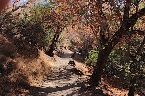
A new walking trail opened up in the city of San Marcos.
It’s inland and a bit of a drive, so it’s best to get there in the early morning or late afternoon because the temps are going up.
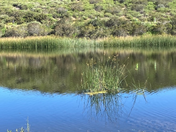
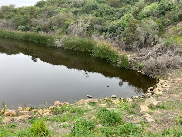
The trail is only a mile or so, not at all strenuous, but the views are magnificent with California lilacs and mature ceanothus surrounding the South Lake Reservoir — built in 1959, although it hasn’t been used as a source of drinking water since 1984.
I doubled back instead of completing the easier loop and that added an extra mile to the hike.
There’s a lot of coastal scrub, coots, ducks, redwing blackbirds, deer, bobcats, and coyotes. I wish I had seen deer; maybe next time! South Lake is also home to a rare native turtle; the Western Pond Turtle, and I’m sorry to say that I didn’t see them, either.
Definitely remember to bring water and a wide-brimmed hat as it gets super toasty in the sun!
To find the universal elements enough; to find the air and the water exhilarating; to be refreshed by a morning walk or an evening saunter… to be thrilled by the stars at night; to be elated over a bird’s nest or a wildflower in spring – these are some of the rewards of the simple life. ~ John Burroughs
Join me on an early morning walk around the lake trails.
There’s a familiar fragrance of tule, which some people don’t like, but I love love the way it smells. Tule grows in dense stands along freshwater wetlands.
Indigenous peoples ate tule roots and seeds, while the reeds were used to make baskets, cord, sandals, and clothing. P.S. Here’s how to say it: “too-lee”
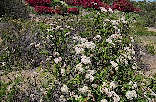
With all the rain we’ve had, everything was uncharacteristically green…as far as the eye could see…
Pretty Black-eyed Susan flowers!
It’s a human-made lake, not natural, intended to be a reservoir, but the ducks and coots don’t seem to mind a bit.
Native buckwheat.
I didn’t see any coyotes this time, but it was still a lot of fun!
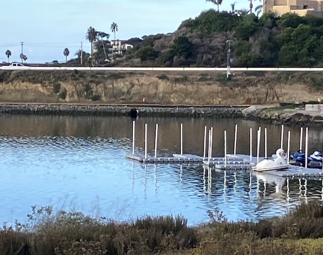
This is my favorite, a swan pedal boat on Agua Hedionda Lagoon. It’s an activity high on the list when the Angels visit this summer. Doesn’t that look like a lot of fun?
Now I’m standing on a path with a view of the trestle bridge and a peek of a blue Pacific ocean. Do any locals know my specific location? I bet not, ‘cos it’s a secret.
After walking all the way around the lagoon, this is a look to the east and a very low tide…
If you block out the electrical poles and the road, it’s easy to transport yourself back in time to when this land was the home of the indigenous Kumeyaay Indian Nation.
This is where they lived, fished, gathered berries, wove baskets, and buried their families. They lived in small family groups which had to move frequently to find new sources of food and water. Each clan wintered in a sheltered valley and migrated into the mountains in the spring.
It’s sacred land and should stay that way in perpetuity.
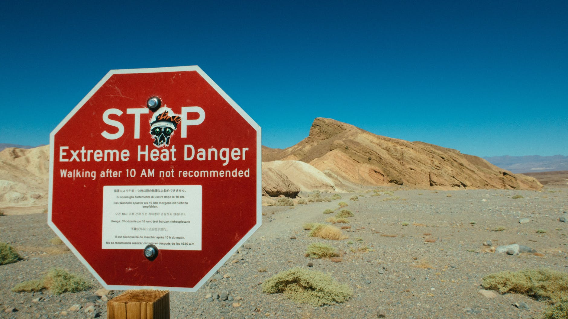
Right now, visitors are flocking to Death Valley National Park to experience the forecasted EXTREME heat.
Death Valley is projected to set a verified world record for the hottest temperature ever reliably recorded, with Furnace Creek expected to reach 131 degrees with a low temperature at night of 101 degrees.
I’ve been to Death Valley a few times. It’s an otherworldly and mysterious experience. It’s a whole mind/body connection, the kind of heat that permeates down to a soulful, cellular level. Along with the magnificent silence, there’s really nothing to compare to desert heat.
Ten thousand years ago, Badwater Basin, the lowest point in North America, was once a hundred-mile long lake. It’s now a vast expanse of salty ground.
When you visit Death Vally, make sure you stop at Artists Palette, a technicolor, kaleidoscopic display of multicolored rock in that makes you feel you’re at an art exhibit.
Of course, as with the rest of our country, there were Indigenous People here before us.
The Timbisha Shoshone Indians lived there for centuries before the first white man entered the valley. They hunted and followed seasonal migrations to harvest pinyon pine nuts and mesquite beans. To them, the land provided everything they needed and many areas were, and are, considered to be sacred places.
I always thank the first people when I camp or hike, no matter where I am.
The shamanic ground markings of Death Valley tend to be found in the more remote parts of this already remote region – probably the reason why any trace of them survives at all. They are ritual and magical features left by long-ago shamans, probably of the ancestral Pima and Shoshone peoples, and they are fragile, so much so that their precise locations are not advertised.
They take various forms – ritual pathways, shrines, vision quest beds, scraped ground markings, strange sinuous lines, and weird patterns of rocks.
Vision quest beds are remote, subtly-marked locations where an Indian brave or shaman would go to spend a solitary vigil seeking a vision – a personal spiritual gift. He would go without food or sleep for perhaps three or four days and nights until the vision came. If it came at all, it would most commonly be in the form of what we would call an auditory hallucination: he would hear a chant or song.
Ritual pathways are probably the rarest of the shamanic features. a loose group of boulders.
The most enigmatic of all the shamanic relics in the valley are markings etched into the hard, sunbaked ground (‘intaglios’) or laid out with small rocks on the surface of the ground (‘petroforms’). Such features are collectively known as ‘geoglyphs’. Both types in Death Valley mainly show meandering, abstract patterns, but a few seem to depict mythical creatures. (Curated from https://www.ancient-origins.net)
If you make it to Death Valley, no matter what season, take more water than you think you’ll need to stay well hydrated!
He’s an amazing British actor, best known for his roles in The Killing Fields,A Room with a View, Warlock, Arachnophobia, Boxing Helena, and Leaving Las Vegas.
He went solo hiking on Mount Baldy In Southern California and was reported missing two months ago on January 13, 2023. Since his disappearance, all of our local mountains have had a record-breaking amount of snow.
His car was found in the parking lot, but no other signs of him. His outcome seems bleak.
This is a treacherous mountain to climb even with the best weather scenario. Others have gone missing, too. Some are found, some never are, nor are their remains located.
I haven’t heard any information about whether he was carrying a GPS location device or a satellite phone, and there hasn’t been an update about the search in quite a while.
I think it’s important to agree that no matter how experienced a hiker, one should never hike alone.
Years ago, my son and friend (both experienced hikers) were on the 10,000 foot Mt. San Jacinto in Palm Springs when there was a blizzard. They missed the last tram down because the winds were gusting to about eighty miles per hour. We were getting really freaked out because they hadn’t called at the agreed upon time. Just as we were about to contact all the officials, a park ranger called to let us know they made it to a ranger station and were OK. Whew! We were so worried!
Poor Julian Sands. Every time I see Mt. Baldy in the distance, I worry about him, too.
NOT the psychedelic kind that Huxley wrote about…but opening the door to self reflection with love and compassion.
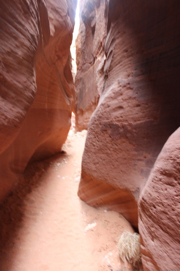
This photo looks like it could be one of my favorite places, a slot canyon in Grand Staircase-Escalante National Monument or here at Vermillion Cliffs, where I snapped this photo.